

Edward Brooke-Hitching is one of the researchers for the very popular and long running BBC quiz programme QI also known as the QI Elves and turned his love of unusual trivia into his first book ‘Fox Tossing, Octopus Wrestling and Other Forgotten Sports’. The Phantom Atlas was his second publication, coming out in November 2016 and very much draws on his love of maps and his own incredible collection of them. Since then he has done three more atlases, one of which ‘The Golden Atlas’ which illustrates famous explorers routes with contemporary maps, I also have in my library. This book however is particularly fascinating as it deals with places that don’t exist yet made it onto maps either in error or in some cases as deliberate fakes. The first of these I want to highlight from the book was one I already knew about and that is The Mountains of Kong.

As can be seen from the map above there is an apparently unbroken line of mountains running across the entire African continent and variations of these appeared on over forty maps by various different cartographers probably starting with James Rennell in 1798. The map illustrated here is by John Cary from 1805 and shows the Mountains of Kong running right across from almost the west coast to eastern Africa and the equally fictitious Mountains of the Moon which were believed to be the source of the River Nile. It was not until 1889 when Louis Gustave Binger gave a talk in Paris and explained that he had been to the site of the Mountains of Kong and not only were there no mountains but there wasn’t even a decent sized hill in sight. However of the over fifty places described and illustrated in detail in the book this is the only one I already knew about, a 6,000km range of mountains that were regularly mapped for almost a century without actually existing being possibly the largest geographical error you can get.
Most of the errors with islands that simply don’t exist is down to faulty navigation and the rediscovery of islands already mapped in their correct location but some are simply works of fiction including at least three islands ‘discovered’ by Benjamin Morrell, one of which he named after himself.
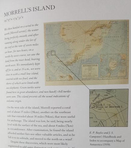
Morrell’s Island along with another of his fakes, Byers’s Island survived on charts for well over a century and both even made it through the British Admiralty’s 1875 cull of 123 islands from their charts that they didn’t believe existed although three of these turned out to exist after all. It is details like this that make Brooke-Hitching’s book so fascinating, he also has sections of the fabulous beasts included on various ancient maps such as Blemmyes a race of headless people with their faces in their chests that appear on the Nuremberg Chronicle map or the Sea Pig from The Carta Marina. It is the vast array of old maps illustrated in the book that are its prime interest to myself, I have a few old maps but nothing like the collection that Brooke-Hitching has to hand. One final example from the book shows just how far back this false history goes with the Cassiterides which the ancient Greeks believed were where the Phoenicians sourced their tin.
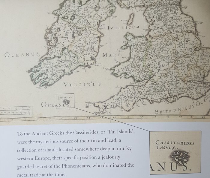
The map above is from 1694 and includes the Tin Islands as they became known as a somewhat enlarged and moved version of the Isles of Scilly which was pretty close to reality as the actual source was Cornwall, the English mainland county just to the east of these islands.
There are lots more examples of dodgy geography in the book which is well worth acquiring if you have any interest at all in maps, at over 250 pages it superbly covers its subject and from the acknowledgements at the back it is clear that Brooke-Hitching does indeed own a lot of the maps featured in his work. The book was published by Simon & Schuster who have also published Brooke-Hitching’s other works.
